|
|
Post by Host Tomas on Mar 4, 2011 19:15:26 GMT -5
Common survivors, take a seat... We're starting... 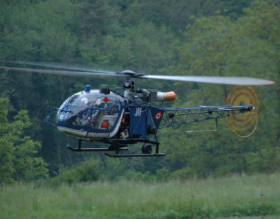 |
|
|
|
Post by Host Tomas on Mar 4, 2011 19:15:57 GMT -5
Our first stage...
Bratislava, capital city of Slovakia. With a population of about 431,000. It's city full of comfort and luxury, but also full of bale just like every capital. It is the seat of the Slovak president, the parliament, and the executive branch of the government. It is home to several universities, museums, theatres, galleries and other important cultural and educational institutions.[3] Many of Slovakia's large businesses and financial institutions are also headquartered there. What do you think, which name had been Bratislava named in former times?
 [/center] |
|
|
|
Post by Host Tomas on Mar 4, 2011 19:17:09 GMT -5
2nd stage Piestany. My heartone. I was born here, i live here i like this town. It is the biggest and best known spa town in Slovakia and has around 30,000 inhabitants.Piešťany is situated in the western part of Slovakia, in the valley of the Váh river, at an elevation of 162 m . The Považský Inovec mountains form the eastern boundary of this part of the Váh valley. The highest hill of these mountains, Inovec 1,042 m , is about 25 km (16 mi) north of the town. The hills immediately east of the town (10 km (6 mi) away) reach a height of about 700 m On the western side, the valley boundary is formed by the Little Carpathians, which are somewhat lower and further away from the town. Just for fun... Do you know a name of some (everyone) of Spa houses here in piestany?   |
|
|
|
Post by Host Tomas on Mar 4, 2011 19:17:24 GMT -5
Považský Inovec is a mountain range in western Slovakia, named after the Váh river. It's near to my born city, Piestany. It is 48 km (30 mi) long and 15-25 km (9-16 mi) wide mountain range. It is situated from the city of Hlohovec, raising from the Danubian Hills, and slowly raising further north until nearly to the city of Trenčín where it borders the Strážov Mountains, where is also the highest hill of the entire mountain range, Inovec (1042 m). The mountain range separates basins of the Váh and Nitra rivers. There are many monuments in or near the mountain range, including Great Moravian hillfort Kostolec near Ducové, Hlohovec Castle near Hlohovec, Beckov Castle near Beckov, Topoľčany Castle and Tematín Castle. Are you so clever to name me highest mountain in Povazsky Inovec?  |
|
|
|
Post by Host Tomas on Mar 4, 2011 19:17:45 GMT -5
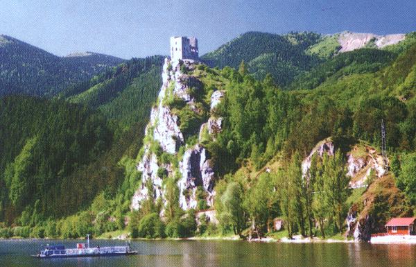
The Strečno Castle is a Gothic castle in northern Slovakia, 7 km east of Žilina. It's really old monument which had been built to big rock just over old road (now it's there highway  ). It's one of the most famous slovakian castles and also one of them which are in good health till now. ). It's one of the most famous slovakian castles and also one of them which are in good health till now.
You know, just few meter underneath Strečno there is a river. One of big ones in slovakia. Are you so smart to name me this river ?
 |
|
|
|
Post by Host Tomas on Mar 4, 2011 19:18:24 GMT -5
Orava is the traditional name of a region situated in northern Slovakia. Orava is now recognized as one of Slovakia's 21 tourist regions, however, it isn't an administrative region unlike its predecessor. In Slovakia, Orava is divided between Dolný Kubín, Tvrdošín, and Námestovo districts in the Žilina Region. It has an area of 1,661 km²[1], with the population on the Slovak side around 126,000.[2] The village of Oravská Polhora is the northernmost point of Slovakia. The major town on the Slovak side (and also the seat of the former county) is Dolný Kubín. I have question on you also here... it's sure that orava is on northern border of slovakia, name me one neighbour of Slovakia and also Orava (means that which other country adjoins Slovakia as well as Orava)  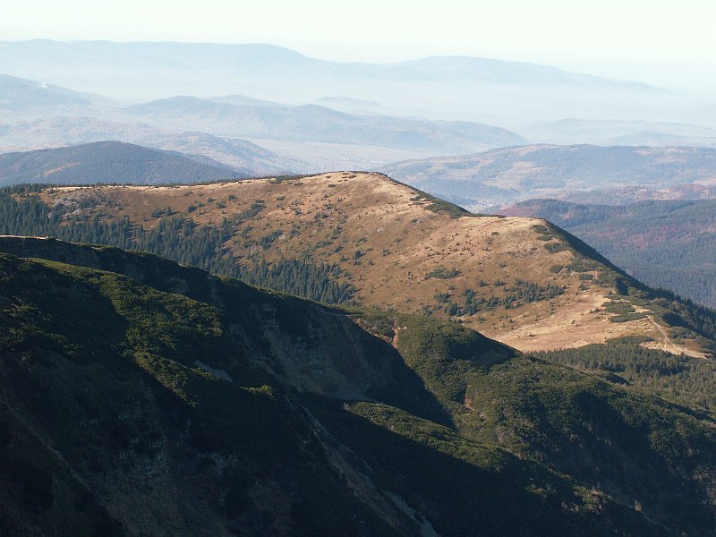 |
|
|
|
Post by Host Tomas on Mar 4, 2011 19:18:47 GMT -5
Now, Liptov members, it's your time
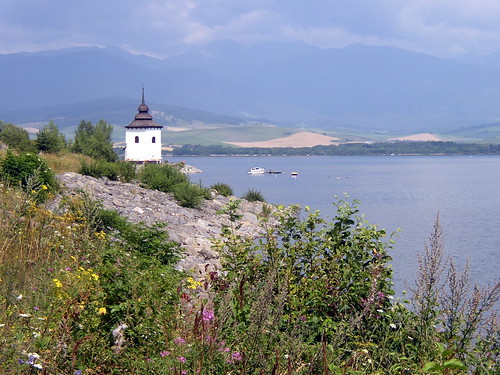
Liptovská Mara is a reservoir in northern Slovakia, on the Váh river in the Liptov region. The dam is named after one of the inundated villages.
It was built in 1965-1975. The area of the reservoir is 22 km², max. depth is 45 m and the capacity is 360 mil. m³. During construction, nine were inundated and a major railway and road relocated. The main purpose of this dam is to prevent floods, although it also generates electricity.
Today, the dam is used as a recreational site. The reconstructed Celtic oppidum Havránok is situated on a hill above the dam. Now you know, about what had you been named... I have question of you, name me a big town near Liptovska Mara, which name is really similar to the name of reseivor.
 |
|
|
|
Post by Host Tomas on Mar 4, 2011 19:19:05 GMT -5
On other hand, now it's your time Tatra
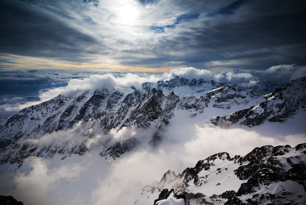
High Tatras or High Tatra (Slovak and Czech: Vysoké Tatry, Polish: Tatry Wysokie) are a mountain range on the borders between Slovakia and Poland. They are a part of the Eastern Tatras Mountains.The High Tatras, with their 11 peaks over 2500 m AMSL, are, together with the Southern Carpathians, the only mountain ranges with an alpine character in the whole 1200 km length of the Carpathian Mountains.
The major part and all the highest peaks of the mountains are situated in Slovakia. The highest peak is Gerlachovský štít at 2,655 m. Many rare and endemic animals and plant species are native to the High Tatras. Large predators, such as the bear, Eurasian lynx, marten, wolf and fox live there.
The area is well known for winter sports. Ski resorts include Štrbské pleso, Starý Smokovec and Tatranská Lomnica in Slovakia and Zakopane in Poland. The town of Poprad is the gateway to the Slovak Tatra resorts.
The first European cross-border national park was founded here—Tatra National Park—Tatranský národný park.
Which is very interesting, is that Parts of the Eragon movie were filmed here.
My question is, do you know highest mountain of high tatras (and highest mountain of Slovakia in global lol) ?
 |
|
|
|
Post by Host Tomas on Mar 4, 2011 19:19:35 GMT -5
The Branisko Tunnel is a road tunnel in eastern Slovakia. Just when high tatra's ends. It is located on the D1 motorway. It replaced the Branisko Pass road via mountain range of the same name, with the top at 751 m AMSL. Currently only one tube is open to traffic; the second tube is expected to be opened in the future.
Construction began when the exploration gallery driving was launched in April 1996 on the axle of the northern (left) tube. The southern tube driving started in May 1997 from both portals using New Austrian Tunnelling method (NATM).[2] Works were slowed down in 1999 due to cost cutting for motorway constructions.
The road in the tunnel is 7.5 m wide, with 1 m wide sidewalks on both sides; maximum height is 4.5 m, maximum gradient is 1.2%. The maximum allowed speed in tunnel is 80 km/h. It's longest tunel here in Slovakia.... Do you know how long this tunnel is??

|
|
|
|
Post by Host Tomas on Mar 4, 2011 19:19:50 GMT -5
Košice (Slovak pronunciation: [ˈkɔʃɪt͡sɛ] ( listen); also known by alternative names) is a city in eastern Slovakia. It is situated on the river Hornád at the eastern reaches of the Slovak Ore Mountains, near the border with Hungary. With a population of nearly 242,001, Košice is the second largest city in Slovakia after Bratislava. Being the economic and cultural center of eastern Slovakia, Košice is the seat of the Košice Region and Košice Self-governing Region, the Slovak Constitutional Court, three universities, various dioceses, and many museums, galleries, and theaters. Košice is an important industrial center of Slovakia. The U. S. Steel Košice steel mill is the biggest employer in the region. The town has good railway connections and an international airport. The city has a well preserved historical center, which is the largest among Slovak towns. There are many heritage protected buildings in Gothic, Renaissance, Baroque, and Secession styles with Slovakia's largest church - St. Elisabeth Cathedral. The long main street, rimmed with aristocratic palaces, Catholic churches, and townsfolk's houses, is a thriving pedestrian zone with many boutiques, cafés, and restaurants. The city is well known as the first settlement in Europe to be granted its own coat-of-arms. In 2013, it will hold the European Capital of Culture title together with Marseille, France. Also, very important, Kosice had my favourite ice-hockey team. HC Kosice So my question will be a bit different. How many Slovakian championships did HC Kosice win? 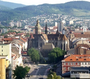  |
|
|
|
Post by Host Tomas on Mar 4, 2011 19:20:23 GMT -5
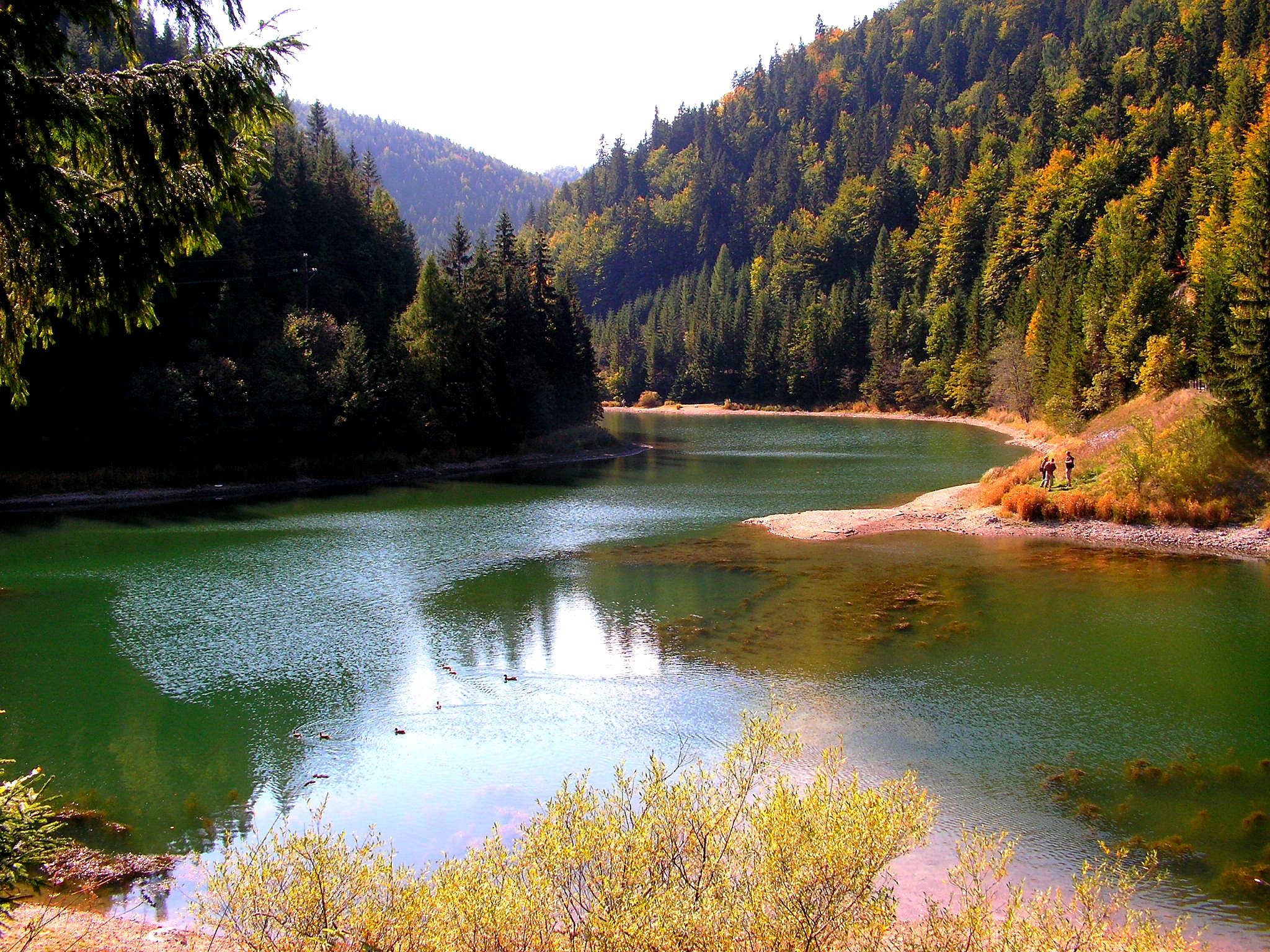
Slovak Paradise (Slovak: Slovenský raj) is a mountain range in central Slovakia. It is a part of the Spiš-Gemer Karst, which in turn is a part of the Slovenské rudohorie Mountains, a major subdivision of the Western Carpathians.
It is located between the towns of Spišská Nová Ves in the north and Dobšiná in the south. It is particularly known for its gorges and waterfalls.
It is very popular with hikers as it has a number of unusual routes through gorges and waterfalls. There are numerous sections where fixed ladders are used to climb.
The area is protected by the Slovak Paradise National Park (Národný park Slovenský raj).
Can you name me one animal and one flower specific for this area??
 |
|
|
|
Post by Host Tomas on Mar 4, 2011 19:20:35 GMT -5
Okay and we are back on the west....The Danubian Lowland or Danube Lowland (Slovak: Podunajská nížina) is the name of the part of Little Alföld (Slovak: Malá dunajská kotlina) situated in Slovakia, located between the Danube, the Little Carpathians and all other parts of the Western Carpathians. It is an extensive tectonic depression filled with layers of Neogene Quaternary to a height of between 100 and 350 meters. It consist of the following two parts: Danubian Hills (also translated as Danubian Upland) in the north Danubian Flat (also translated as Danubian Plain) in the south Many urban and other settlements can be found in this primarily agricultural area. The towns Topoľčany, Nové Zámky, Komárno, Levice, Dunajská Streda and Galanta are administrative centers. They are centers of industry and the processing of agricultural products (mills, breweries etc.). Old wine growing towns (Svätý Jur, Pezinok, Modra) and health resorts (Piešťany, Dudince) can be also found in the lowland. See the articles of the two subdivisions for further information. Same question like in Orava stage. Danubian lowland is situated at the border on our state. To which other state is danubian lowland neighbour?  |
|
|
|
Post by Host Tomas on Mar 4, 2011 19:21:04 GMT -5
Okay so this is end of your trip, and also your reward... thanks for your attention...
but.... here's the twist!!!!
2 of you will be reward by 2 rewards... one reward is smaller then first but i think that both are very very good in this game. This reward are beyond 2 stages (or 2regions if you want) and you can choose them.
But Here's the deal and here's how....
First step - you probably noticed my questions on every stage. You have to answer all of them, and then send me PM with answers...
Second step - once i receive your answers i accept them or i ll write you which one is incorrect and you can change that. Once i receive your answers you can already take your stage... (if your answers are incorrect your spot won't count till you make them correct )
stages -
Bratislava -
Piestany -
Povazsky Inovec -
Strecno -
Orava -
Liptovska Mara -
Tatry -
Tunel Branisko -
Kosice -
Slovensky Raj -
Dobsinska Jaskyna -
Podunajska Nizina -
for example, i wanna Tatry spot... so i ll post answers, and then i ll choose Tatry - Tomas (then host write me that i am correct so i'm waiting only for results )
Here's one spot for everyone. You cannot take spot which is already taken !!!! But if taken spot have no answers or no correct answers, WILL NOT be counted as REWARD
worth playin for ?:)GO !
p.s. im not gonna wait on everybody... if this takes too long, i am not gonna keep everyone enought time to choose his stage |
|
Staton
Merged Tribe 
Posts: 277
|
Post by Staton on Mar 4, 2011 19:27:50 GMT -5
so we just answer the question for the spot we want or we have to answer all the questions
|
|
|
|
Post by Host Tomas on Mar 5, 2011 3:34:38 GMT -5
you have to answer every question, then you can choose your spot |
|


 ). It's one of the most famous slovakian castles and also one of them which are in good health till now.
